Kids had gone back to school, the boat was much less crowded and we had to travel a bit further south down Jeffrey's ledge to find whales. Most likely the humpbacks were getting ready to migrate. They needed to add as much body fat as they could to make the long journey to the Carribean. There they would have their calves, or mate and then make the same trip back to the northern Atlantic without feeding again until they returned!
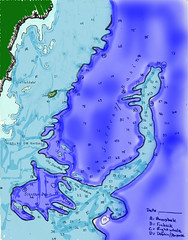
THE MAP:
Measurements are in fathoms (1 fathom= 6 feet) So:
- The * on green is Kennebunkport where our boat was anchored.
- Light blue is as much as 20' deep.
- medium blue as much as 180' deep
- dark blue is as much as 600' deep
If you click on the map it will take you to a larger version that has notes. Run your mouse over the surface of the map and more notes will show up.